Monday, December 05, 2005
The pressure is on
The wind is howling out there this morning. Oh, it has howled on many days here in Fort Collins, but today could well be the windiest day we've experienced since moving here. And here's why: 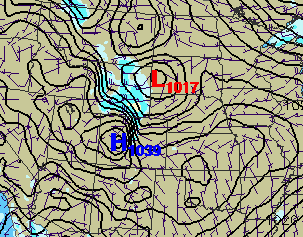 (Map courtesy of RAP/UCAR). This is the 1300Z (7am MST) surface pressure map. Between the 1039 high and the 1017 low, we have a very steep pressure gradient right across the mountains. With mountain effects like gap winds and rotors exacerbating the situation, the NWS has issued a high-wind warning for foothills locations:
When they talk about winds aloft, they're referring to maps like this: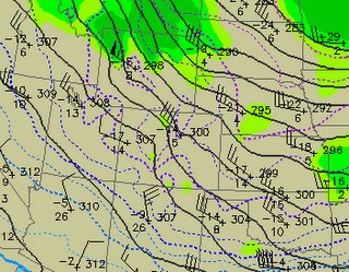 (Also courtesy of RAP/UCAR). This depicts winds blowing at the 700mb level, which corresponds roughly to 10,000 feet elevation. See the close contour lines, and the little flag symbol with 4 long lines "blowing" toward the NW, around Denver? That means that the actual balloon sounding from this morning measured 40kt (~ 45mph) winds above Denver at around 10k ft. That's important because when the sun rises, winds aloft tend to get "mixed" down to the surface in the form of turbulent gusts. And when that happens at the same time there's a strong surface gradient, well, you're talking a very, very windy day. And potentially dangerous for highway travelers.
This time of year seems to see rapidly intensifying surface pressure systems, and when the highs and lows get onto opposite sides of the Front Range, that's when we get the gusty mountain winds. Good thing I had all our leaves raked weeks ago!
tags: weather meteorology wind
 (Map courtesy of RAP/UCAR). This is the 1300Z (7am MST) surface pressure map. Between the 1039 high and the 1017 low, we have a very steep pressure gradient right across the mountains. With mountain effects like gap winds and rotors exacerbating the situation, the NWS has issued a high-wind warning for foothills locations:
 URGENT - WEATHER MESSAGE
NATIONAL WEATHER SERVICE DENVER CO
456 AM MST MON DEC 5 2005
...HIGH WINDS COLORADO NORTH CENTRAL MOUNTAINS AND EASTERN SLOPES TODAY...
.INCREASING WINDS ALOFT AND AN INCREASING CROSS MOUNTAIN SURFACE
PRESSURE GRADIENT WILL PRODUCE HIGH WINDS IN THE COLORADO NORTH
CENTRAL MOUNTAINS...ADJACENT EASTERN FOOTHILLS...WESTERN URBAN
CORRIDOR AND SOUTH PARK TODAY.
When they talk about winds aloft, they're referring to maps like this:
 (Also courtesy of RAP/UCAR). This depicts winds blowing at the 700mb level, which corresponds roughly to 10,000 feet elevation. See the close contour lines, and the little flag symbol with 4 long lines "blowing" toward the NW, around Denver? That means that the actual balloon sounding from this morning measured 40kt (~ 45mph) winds above Denver at around 10k ft. That's important because when the sun rises, winds aloft tend to get "mixed" down to the surface in the form of turbulent gusts. And when that happens at the same time there's a strong surface gradient, well, you're talking a very, very windy day. And potentially dangerous for highway travelers.
This time of year seems to see rapidly intensifying surface pressure systems, and when the highs and lows get onto opposite sides of the Front Range, that's when we get the gusty mountain winds. Good thing I had all our leaves raked weeks ago!
tags: weather meteorology wind
Comments:
Post a Comment
![]()
 | ||