Saturday, December 03, 2005
Weatherblogging
Haven't done nearly enough of this these past couple years....
Let's take a look at the overnight forecast discussion from the Boulder NWS office:
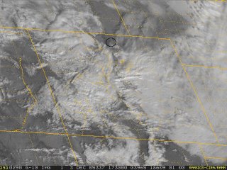
We had our first real snowfall of the season last night. It was only about an inch or so, but we awoke to see white streets, yards, and rooftops. However, the sky has cleared off the past hour or so, and the satellite image shows some clear air upstream of where we are (in the black circle):
 That huge patch of white in the southeast central part of the state is the larger snowfield - in Fort Collins we were on the very northern fringe of the snowfall. Cindy reported to me on a walk up the local ridgetop here this morning before the sun came out that the snow ended just north of town, and didn't seem to even extend that far east of here either. The satellite seems to suggest that too. By now though, any snow here in the direct sun has melted.
One thing I still have a hard time understanding is why forecasters still think of "dynamics" and "Q-G omega" as somehow separate entities. They're the same freakin' thing! I may not be in meteorology anymore, but if there was one thing that stays with me, it's that. Ugh.
tags: weather, meteorology, national weather service
Let's take a look at the overnight forecast discussion from the Boulder NWS office:
FXUS65 KBOU 031023
AFDBOU

AREA FORECAST DISCUSSION
NATIONAL WEATHER SERVICE DENVER CO
320 AM MST SAT DEC 3 2005

.SHORT TERM...TDA-TNGT...BANDED JET STREAM INDUCED SNW SHWRS CONT
TO GRADUALLY MOVE OFF THE MTNS AND OVR THE NERN PLAINS THIS MRNG
WHILE RADAR CONTS TO SHW AMPLE PCPN OVR WRN CO WITH MORE PCPN
FORMING FARTHER TO W OVR NRN UT. MDLS CONT TO SHW COOLING ALF
THRU PRD AND MSTR OVR MTNS UP TO NR H5 LVL SO WILL KEEP HI POPS
IN MTNS THRU PRD. OROGRAPHIC SNW MDL GAVE ONLY LGT AMTS OF SNWFL.
GUD DYNAMICS TDA AND UPWRD Q-G OMEGA BUT AMS BCMS SUBSIDENT TNGT.
SO WILL KEEP THREAT OF PCPN OVR PLAINS TDA BUT ONLY IN MTNS TNGT.
GFS TENDS TO HANG ON TO MSTR OVR PLAINS LONGER THAN GFS. TEMPS
WILL BE MUCH COOLER ESPCLY ON PLAINS. WILL MAKE ONLY SML CHNGS
TO MOS TEMP GDNC VALUES WHICH ARE CONSISTENT WITH H7 TEMPS.
WILL CANCEL WNTR STRM WRNG FOR MTNS WITH MRNG FCST ISSUANCE.
We had our first real snowfall of the season last night. It was only about an inch or so, but we awoke to see white streets, yards, and rooftops. However, the sky has cleared off the past hour or so, and the satellite image shows some clear air upstream of where we are (in the black circle):
 That huge patch of white in the southeast central part of the state is the larger snowfield - in Fort Collins we were on the very northern fringe of the snowfall. Cindy reported to me on a walk up the local ridgetop here this morning before the sun came out that the snow ended just north of town, and didn't seem to even extend that far east of here either. The satellite seems to suggest that too. By now though, any snow here in the direct sun has melted.
One thing I still have a hard time understanding is why forecasters still think of "dynamics" and "Q-G omega" as somehow separate entities. They're the same freakin' thing! I may not be in meteorology anymore, but if there was one thing that stays with me, it's that. Ugh.
tags: weather, meteorology, national weather service
Comments:
Post a Comment
